How to Get Around Vancouver: Tips, Costs, and Advice
The Canadian city of Vancouver offers residents and tourists a public transportation system that is efficient and affordable. The available transport modes are diverse, integrated, and include ferries, the subway, trolleybuses, and buses. By using the public transport service, users can move quickly around the city and easily reach every area, including beaches and ski resorts. Thanks to this service, car rental is unnecessary, and using public transport is a pleasant and convenient way to experience and explore the city.
If you are planning a trip to Canada, here is a guide on how to get around Vancouver: tips, costs, and advice!
Useful Tips

The public transportation system in Vancouver is called Translink and includes buses, ferries, and the subway. All modes are typically available from 5:00 AM to 2:00 AM, with specific schedules for each line and mode. There is no recommended mode over another; the system is integrated, favoring seamless transfers between services. A unique fare system with prepaid cards has also been established for use across all modes. Both single-ride tickets and the card can be purchased at stations and many stores, supermarkets, and convenience stores, and a refundable deposit of $6.00 (€3.88) is required.
To explore individual neighborhoods, walking or biking is recommended, as biking is favored and used both by locals and tourists. The city is quite large, so for a first visit, we recommend a 4-hour guided tour to identify landmarks and learn about attractions and the city's history. Even if you decide to bike, we suggest taking a guided bike tour first to familiarize yourself with bike paths and traffic. Alternatively, especially if you have limited time, we recommend the classic hop-on hop-off bus.
Finally, with the large harbor, the Fraser River, and the Georgia Strait separating it from Vancouver Island, water plays an important role in the city. Therefore, we strongly recommend not to miss the scenic tour from the water, to admire the city from a different perspective!
- Recommended solutions and transport modes: by bike, bus, on foot, ferries, SkyTrain (subway)
- Not recommended solutions and transport modes: car, taxi
- Recommended city card and subscriptions Compass Card (from $6.00/€3.88 - see details), daily public transport ticket (from $10.50/€6.80)
How to get from the airport to downtown Vancouver
Vancouver International Airport is the second most important airport in Canada, after Toronto, and is the hub for Air Canada. From 2010 to 2018, it also won the Skytrax award for best airport in North America! It is located just 15 km south of downtown and can be easily reached by the Canada Line train or by taxi. No bus services are available.
- Distance from downtown 15 km / travel time: 25 min;
- By train SkyTrain line - The Canada Line / ticket cost: $8.75 (€5.66)
- By taxi average cost $33.00 (€21.36) / travel time: 30 min
How to Get Around on Foot

Vancouver is beautiful to explore on foot, especially during the nice weather. The central areas are even more concentrated, and it takes about an hour to cross the city from east to west (approximately from Stanley Park to Chinatown) on foot, and only half an hour to traverse the peninsula from north to south.
For an initial exploration of the city, we recommend a 4-hour tour of the city's attractions, ideal for understanding the layout of the city and identifying landmarks. If you are curious about Canadian culinary culture, we suggest the Gastown Food Tour, the oldest neighborhood in Vancouver, featuring cobblestone streets, craft beers, and numerous tastings of local cuisine!
In any case, to get from one neighborhood to another, biking or using public transport is recommended, given the efficiency of the transportation system and the presence of many bike lanes.
How to Get Around by Bicycle

Biking is a very loved and utilized mode of transportation by both residents and tourists, prized for its green aspects, but also because the city encourages biking through a comprehensive network of bike paths.
For a first contact, it's advisable to first take a guided bike tour to get accustomed to the bike paths and traffic.
A downloadable map has been created for residents and visitors, updated annually, showing the routes specifically designed for bicycles. The city's bike sharing service is called Mobi by Shaw Go and has been active since 2016, allowing you to pick up your bike at various docking stations (approximately 125 stations, with a total of about 1,200 bikes). Mobi is a service designed specifically for getting around the city and for relatively short distances, available by purchasing a pass for 24 hours, 30 days, or one year at corresponding prices of $12.00 (€7.68), $25.00 (€16.00), and $129.00 (€82.58).
Using Public Transport

As mentioned earlier, Vancouver's public transportation is managed by the Translink company, is modern and efficient, and allows access to every corner of the city. Buses, the subway (SkyTrain), and ferries (SeaBus) are part of an integrated system and can be used by purchasing single tickets or the "compass card", a convenient reloadable card. On the official website of the company, a "trip planner" is also available, allowing you to plan journeys between stations.
If you want to enjoy a scenic ride around the city, we also recommend the tourist bus, which will allow you to easily reach all the main attractions of the city, thanks to stops located in strategic points where you can hop on and off as you please! But Vancouver is also a city situated on the water, so one of the best activities to do is definitely the scenic tour from the water, lasting 90 minutes on a raft. For the more adventurous, there is also the option to participate in a scenic tour by seaplane, admiring the city from above!
Buses
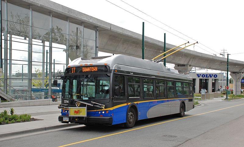
Buses operate comprehensively throughout the city, from central neighborhoods to more peripheral ones. Waiting times are between 5 and 15 min, and this can be verified on a dedicated display at the most modern and frequented stops.
The lines most used by tourists are 5 to reach Robson Street, 6 to Davie Street, 10 to the nightlife district of Granville Street, 4 to the campus of the University of British Columbia, 2 connecting Kitsilano Beach to downtown, and 19 for Stanley Park.
- Hours from 5:00 AM to 1:00 AM
- Single ticket price $2.75 (€1.78)
- Cost of booklet of tickets/subscription daily ticket $10.50 (€6.80)
SkyTrain
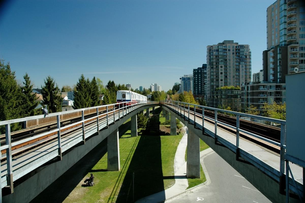
This is the subway that connects downtown to peripheral areas, called SkyTrain since most routes are elevated, offering obvious tourist advantages as they allow you to enjoy a beautiful panorama during the ride.
There are three active lines: the Expo Line, which connects Downtown Vancouver to Surrey, in the eastern part of the city; the Millennium Line, which follows a circular route from east to west along the waterfront area next to the sea; and the Canada Line that heads south, stopping in Richmond and at the airport.
The main tourist stops are Commercial-Broadway Station, featuring restaurants and shops on Commercial Drive, Burrard and Granville Station, which are close to downtown, and Waterfront Station, which connects the harbor area.
- Hours from 5:00 AM to 1:30 AM
- Single ticket price varies based on the three zones into which the city is divided, from $2.75 (€1.78)
- Cost of booklet of tickets/subscription daily ticket $10.50 (€6.80) or Compass card
SeaBus

With the SeaBus ferries, you can reach the northern area of Vancouver in about 15 min, but they also provide a quick alternative to cross Burrard Inlet. These vessels offer an interesting view of the city, as they travel more scenic and enchanting routes, especially at sunset.
The SeaBus departs every 15-30 min depending on the time of day and charges a fare not based on distance, which is always the same, but rather on the time, because during peak hours, the fare for zone 2 is charged, while the rest of the day it is charged for zone 1.
- Hours from 6:00 AM to 1:00 AM
- Single ticket price from $2.75 (€1.78) to $4.25 (€2.75)
- Cost of booklet of tickets/subscription daily ticket $10.50 (€6.80) or Compass card
By Car

Like any town, even with orderly and relatively light traffic, Vancouver has parking issues. Downtown, indeed, parking can be hard to find and expensive compared to the convenience and comfort of public transportation.
This aspect is one of the reasons why car rental is not recommended, in addition to time considerations. Due to its layout and organization, to reach the peripheral area of North Vancouver, opposite the port, it takes about 15 min by ferry, but longer by car, as the route takes you out of the center, which is surrounded on three sides by water. Therefore, it requires a longer detour with bridge crossings that are always heavily trafficked, especially during rush hours.
Parking and Stops
In the central areas of Vancouver, finding paid parking in classic blue-striped areas is quite a challenge, not to mention the high costs. In any case, if you decide to use a car to reach downtown, the average cost of street parking is $1.50/h (€1.00) for a maximum stay of 2 hours. The most affordable and nearest parking to downtown Vancouver is the underground lot at 900 Howe Street ($5.50/€3.52 per hour) and the lot at 843 Seymour Street ($2.50/€1.60 per hour). It's also possible to pay for parking using various smartphone apps, depending on the area.